#LANDSCAPING AND URBAN PLANNING PROJECTS
LandWave
Peters Park occupies a plot of land in Boston’s South End that was actually water before the city was built up in the 19th century.
The park coincides with the Neck to the Shawmut Peninsula, a historic location without a trace of its watery past. Local residents formed the Neck Art Project to create an artwork to mark the site, commissioning Ground to design and build LandWave. They answered some questions about the installation.
What were the circumstances of receiving the commission for this project?
Two stages: a call for qualifications followed by a design proposal and presentation.
LandWave was the product of a community initiative. A very small team of community volunteers originated the project, raised all of the funds and managed the process and public interface. The selection process spanned five years, two community clients, one fiscal agent, 50 community residents, a visioning workshop, pubic presentations, an exhibit and a two year hiatus prior to the selection of the designers. Eventually three teams were shortlisted to develop design proposals. In October, 2005 the Gillies-Smith/ Kilkelly/Cormier design team was selected.
Can you describe your design process for the artwork?
The competition brief was to commemorate the historical location of the Neck; a skinny isthmus less than 100 feet wide that once was the only land entry into Boston. This slender neck of land is entirely unrecognizable now due to extensive fill (the breadth of land in the same locations is now several miles wide).
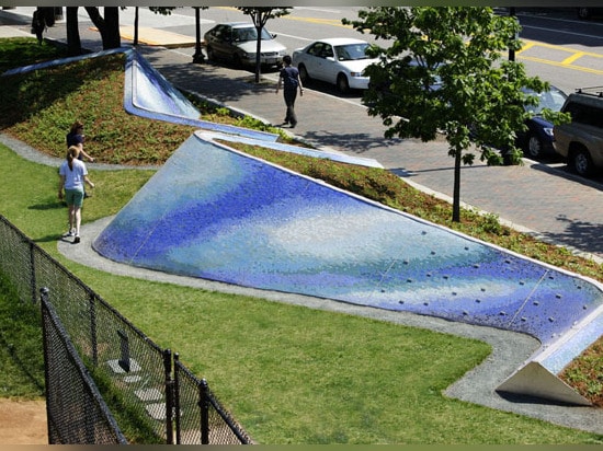
As landscape architects we were interested in the terrestrial history of the site; a history that is shared across cultures. As is common in urban locales, the solid ground that we stand on has been massively reshaped by humankind. We were fascinated by the profound yet simple and prevalent story that, where was once water, now is land. LandWave recalls the making of land out of water.
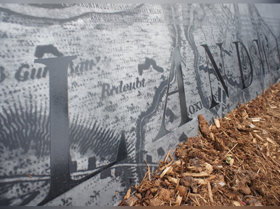
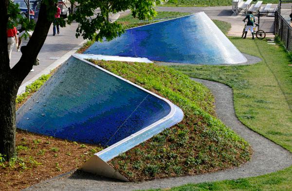
Two twisting wave-like landforms are covered on one side with a green land-like groundcover, and on the other, a range of blue mosaic tiles that emulate the texture and color of a water wave; metaphorically a wave of land and water. At night, the flowing crest of the waves is traced by a blue LED ribbon. At the end of one wave an engraved stainless plate includes a map of the site as it existed in 1630 displaying the neck in its original supermodel litheness.
How does the completed artwork compare to the project as designed? Were there any dramatic changes between the two and/or lessons learned during construction?
The design path was marked by two dramatic changes. The first occurred as soon as we were awarded the project; the site changed from a paved site on the southeast side of Washington Street to a park site on the northwest side. While retaining the land/ water concept, the project correspondingly changed from street furniture to landform.
The second change occurred during the budgetary climate of the fall of 2008. Two anticipated funding sources fell through, representing approximately 1/3 of the budget. The design response was to change from a three-wave scheme into two waves through reworking of the geometries and layout.
How does the landscape compare to other projects in your office, be it the same or other types?
Our work is characterized by visually expressive urban landscapes. Occasionally, when the right one comes around we do public art projects. We view these smaller projects as testing grounds for ideas and methodologies.
Often, the type of work we do is a little in your face; we use the phrase the “visible landscape”. In part, our interest springs from the visceral pleasure of conceiving and experiencing the work. However there is also another agenda. We believe it critically important that our complete urban landscape (of parks, streets, sidewalks and the like) is understood as a designed environment, the product of substantial financial and design investment. Overly recessive landscapes can easily be dismissed to the periphery of consciousness as green or grey background. As a culture we need to understand that every element of our urban landscape is the product of many design decisions and that to improve the quality of our urban environment we need to make different choices. The first step to having a higher quality built environment is to expect one. We hope our work helps to bring urban landscapes, whether hard or soft, into focus.
How does the project relate to contemporary architectural trends, be it sustainability, technology, etc.?
In North America current landscape thinking primarily views landscape architecture as a series of interrelated systems. The systematic thinking of LandWave manifests at the level of community engagement, an incremental urbanism of engagement.
Once we start viewing sustainability as more than a technical ecological response we understand that, by necessity, there is a cultural component to it. As we face challenges presented by environmental changes, the collaboration between individuals in communities is vital. LandWave serves as a reminder of both the land history of the local site, and the power of the community to shape its neighborhood and relationship to the environment. The extensive community process and product of LandWave encourages local residents to become even more invested in their community, to maintain and enjoy the integrity of the place over time.
Are there any new/upcoming projects in your office that this one’s design and construction has influenced?
We haven’t been able to kick the compound concrete curves out of our blood yet! They keep sneaking into some of our other projects.